Search
Use keywords to search across notebook descriptions

Use keywords to search across notebook descriptions
Besson Street, Mason's Court, Mason's Grove, Martin's Place, New Cross Road, Briant Street, Martha Place, Faulkner Place.
Types of housing, open spaces. Frederick Street.
Not a criminal district, local employment, Roman Catholic Church.
Description of Police Constable Moss. Arica Road, Horsted Road.
Mantle Road, Foxwell Street, Tolhurst Street, Endwell Road, Sprules Street, Walbutton Road.
Penmartin Road, Pepys Road, Pendrell Road, Vesta Road, Reservoir Road, Sandbourne Road, Jerningham Road, Arbuthnot Road, Ommaney Road.
Pepys Road, Jerningham Road, New CRoss Road.
St James' Road, Laurie Grove, Rebecca's Place, Dixon Road, Lewisham High Road, St Donatt's Road, Shardeloes Road.
Peckham Road, Camberwell Glebe, Vicarage Road, Belham Street, Mosedale Street, Datchelor Place, Artichoke Place, Artichoke Mews.
Brindley Street, Shardeloes Road, Malpas Road, Luxmore Street, Rokeby Road, Brockley Road.
Vulcan Road, Vulcan Terrace, Brockley Road, Malpas Road, Harefield Road, Cranfield Road.
Wickham Road, St Peter's Road, Manor Road, Coulgate Street, Foxberry Road, Harcourt Road, Brockley Road.
Wickham Gardens, Glensdale Road, Upper Harefield Road, Cranfield Road, Breakspears Road, Tyrwhitt Road, Albert Road, Tressillian Road.
Clifton Road, Carlton Road, Tressillian Crescent, Crescent Road, Hilly Fields Crescent, Tressillian Road, St Margaret's Road, Arabin Road.
Kneller Road, Braxfield Road, Comerford Road, Whitbread Road, Howson Road, Dalrymple Road, Beecroft Road.
Brockley Road, Holdenby Road, Hazeldon Road, Eddystone Road.
Lack of drainage system Brockley Rise. Brockley Road, Brockley Rise, Holmesley Road, Stondon Park.
Honor Oak Park, Brockley Rise, Whatman Street, Bovill Road, Ackroyd Street, Agnew Street.
Gabriel Street, Lessing Street, Wyleu Street, Honor Oak Park, Ballina Street.
Battles of One Tree Hill. One Tree Hill, Forest Hill Road, The Drive, Honor Oak Rise.
Description of boundaries of walk: on the north east Camberwell New Road; on the west and south by the London Chatham and Dover Railway and South London Railway; on the east Denmark Hill. Part of t...
Station Terrace, Station Vale, Lowth Road, Crawford Street, Morna Road, Denmark Street, Dane's Road, Dane's Cottages, Roslyn Avenue, Lilford Road, Carew Street.
Goodyear Place, Kitson Street, Rust Square, Cumberland Place, Boyton's Place, Bath Place, Sugden Street, Boyton's Road, Victory Square, New Church Road.
Alma Terrace, Flaxman Road, Eastlake Road, Luxor Street, Pomfret Road, Lewis Road, Padfield Street, Vaughan Road, Harbour Road, Cambria Road.
Conderton Road, Bredon Road, Bengeworth Road, Cold Harbour Place, Denmark Passage, Sun Court, Denmark Hill.
General remarks concerning area: open spaces; housing; changes to colours on poverty map 1889.
Description of boundaries of walk: on the north Church Street, Peckham Road; on the east Vestry Road, Grove Park; on the south Champion Hill Terrace, Grove Hill Terrace; on the west Denmark Hill. P...
Windsor Road, Champion Park, Champion Grove, Grove Hill Road, Camberwell Grove.
Canning Passage, Grove Cottages, Church Street, Wilson Road, Dagmar Road, Grace's Road, Maude Road.
Rignold Road known as Bug Island owing to the quantity of vermin. Vestry Road, Linnell Road, McNeill Road, Lyndhurst Grove, Rignold Road.
Lettsom Street, Fowler Street, Fearnley Road, Edgecombe Road, Gillam's Yard, Grove Park, Champion Hill Terrace, Champion Hill.
Woman in Joiners' Yard physically assaulted by her husband. Grove Place, Denmark Hill, De Crespigny Park, Love Walk, Selborne Road, Allendale Road, Cuthill Road, Daneville Road, Joiners' Yard.
House front decorated in Tiger Yard. Cock Yard, Tiger Yard, Wren Shed. Wren Road.
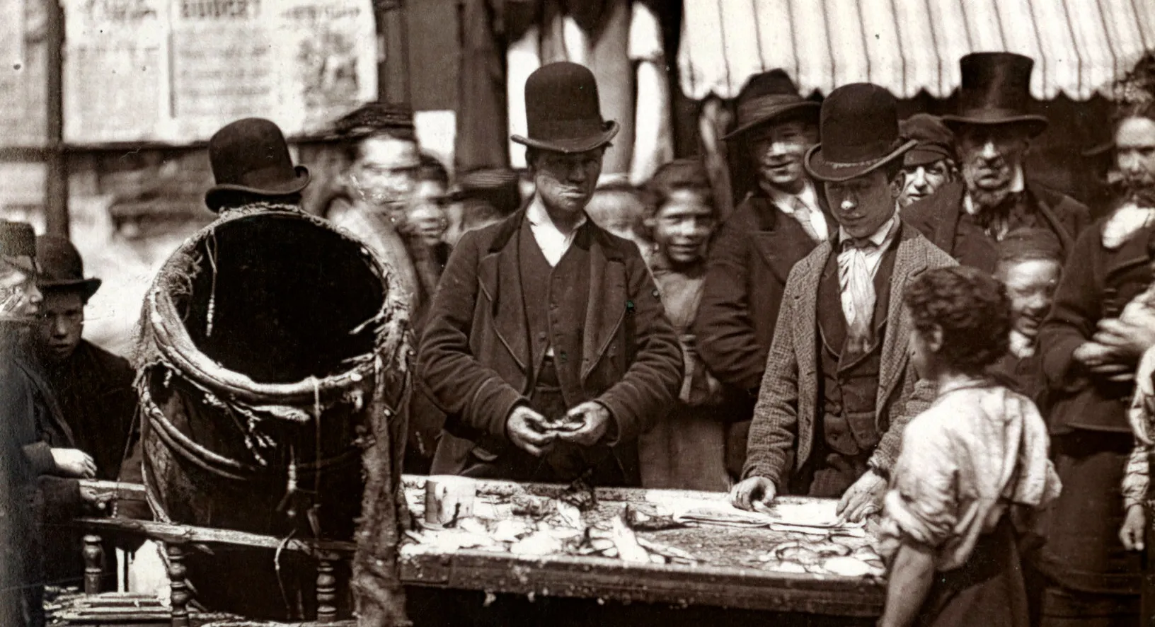
Description of a group of men drinking outside a public house Edmund Street. Edmund Street, Paddock Place, Graycott Place, Westmacott Street, Acorn Street.
Description of boundaries of walk: on the south east Denmark Hill, Herne Hill; on the south west Gubyon Avenue; on the west and north by London Chatham and Dover Railway and South London Railway. P...
Rolls Court Avenue, Cosbycote Avenue, Kestrel Avenue, Shardcroft Avenue, Gubyon Avenue, Fawnbrake Avenue.
Lowden Road, Milkwood Road, Jessop Road, Heron Road, Poplar Walk, Hinton Road.
Herne Hill Road, Alderton Road, Wingmore Road, Wanless Road, Hardess Road, Kemerton Road, Cambria Road.
Employment in the area. Additional streets mentioned in the walk: Anstey Road, Loughborough Park Buildings, Dumbleton Road, Northway Road.
Description of boundaries of walk: on the east and north by the Grand Surrey Canal and Peckham Canal; on the south Commercial Road, Southampton Street; on the west Wells Street. Part of the parishe...
Sumner Road, Castle Square, Shields Street, Nutt Street, Scipio Street, Edward Street, Daniel Street, Alder Street, Davey Street.
Willowbrook Road, Pennick Road, St George's Road, Cator Street, East Surrey Grove, Camden Grove North, Raglan Passage, Tilson Road.
Cottage Green, Wells Street, Parkhouse Street, Southampton Street, Harris Street, Rill Street, Teather Street, Havil Street, Ada Road.
Gloucester Road, Albert Road, Eastdene Street, Cooden Street, Dorton Street, Mason's Cottages, Dragon Road.
Wells Street, Southampton Street, Rainbow Road, Dowlas Street, Bonsar Street, Coleman Road, Peckham Grove, Sanders Road, Blake's Road, Hornby Road, Graylands Road, Fendick Road.
Account of Aves inspecting a blocked toilet and reporting the drainage problem to the local medical officer. Hazelmere Road, Lidgate Road, Diamond Court, Diamond Street, Moody's Cottages, Riddell S...